Research Vessels Begin Biennial Bottom Trawl Survey of Aleutian Islands
Two vessels chartered by Resource Assessment and Conservation Engineering (RACE) Division’s Groundfish Assessment Program are conducting more than 2 months of scientific bottom trawl surveys in the Aleutian Islands, continuing a time series of biennial or triennial surveys that stretches back to 1980. The results of these surveys are used to derive fishery-independent estimates of abundance, distribution, and biological condition for groundfish resources in the Aleutian waters of Alaska.
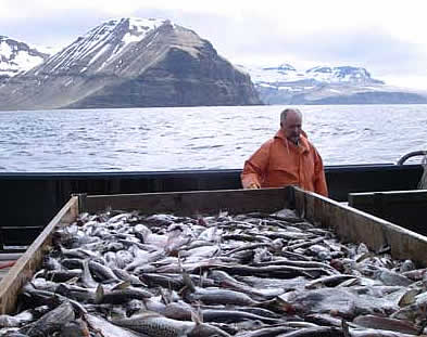
Figure 1. Frank Shaw prepares for sorting a catch of walleye pollock and flatfish aboard the chartered fishing vessel Sea Storm during the 2010 bottom trawl groundfish assessment survey of the Aleutain Islands.
Scientists on the Sea Storm and the Ocean Explorer are expected to complete 420 survey trawl hauls over a 70-day period along the continental shelf and upper continental slope of the southeastern Bering Sea and Aleutian Islands archipelago. They started 6 June in Dutch Harbor and are scheduled to end their charters in Dutch Harbor on 14 August. The boats started the survey near Unimak Pass, surveying stations on the Bering Sea side of the nearer islands of the Aleutian archipelago; west of the Islands of Four Mountains (long. 170°W) they began sampling stations both north and south of the chain. The vessels will continue to work their way westward past Attu Island to Stalemate Bank (long. 171°E). The survey period will be broken into three legs, with breaks in Dutch Harbor on 29 June and in Adak on 22 July.
As of the end of June, when crews completed the first survey leg, about one-third of the stations had been sampled, and the project is on schedule to be completed successfully. Each boat holds six scientists plus the skipper and crew. In addition to core staff from the AFSC, scientists from Humboldt State University, the University of Washington, and the University of Alaska Fairbanks are participating on various legs of the survey.
The biennial survey monitors trends in the distribution and abundance of commercially and ecologically important groundfish species such as walleye pollock, Pacific cod, Atka mackerel, flatfish, and rockfish. It also helps us measure various biological and environmental parameters such as sea surface and bottom temperatures and the size, age, and food habits of important groundfish species. The survey has been carried out every other year since 2000. Before then, it was conducted approximately every 3 years beginning in 1980.
The vessels make 15-minute trawl hauls at randomly preselected stations. The trawl catches are sorted, weighed, and enumerated by species (Fig. 1). Samples are collected from selected species to determine fish sex, size, age, sexual maturity, and food habits. Data on the location and depth of the survey tows, the fishing dimensions and performance of the trawl, and environmental observations are recorded using a variety of monitoring instruments on the vessel or that are attached to the trawl headrope. Sample depths will range from depths greater than 15 m near shore to 500 m on the upper continental slope.
Following completion of the survey in early August, scientists will edit and finalize the data they collected on fishing effort and catch rates. For each species, they will use the data to estimate abundance and describe their geographic and depth distribution. They will also generate estimates of population size and age distributions of the groundfish species that are annually assessed and managed by the North Pacific Fishery Management Council. Results of the survey will be provided to stock assessment modelers and analysts by the end of September. Assessment teams will then combine that information with data from the fishery and results of previous surveys to update the stock assessments.