Habitat Researchers Participate in Long-range Sidescan Sonar Training and Testing
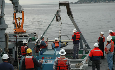
Figure 2. Scientists, engineers, and technicians observe deployment of the Klein 7180 long-range sidescan sonar system during training exercises conducted in Puget Sound, Washington. Photo by Bob McConnaughey.
Members of the Groundfish Assessment Program’s Habitat Research Group received formal operator training for the newly delivered Klein 7180 long-range sidescan sonar system (LRSSS). The LRSSS is a towed underwater platform (towfish) with multiple acoustic, environmental, and navigational sensors which, combined with topside processing electronics, efficiently collects, processes, and archives seafloor and water-column data.
In particular, the LRSSS is capable of very broad coverage at high speeds, as compared to conventional towed systems.This capability increases the area of seabed that can be mapped per survey day thereby improving vessel productivity. The technology is innovative and applicable to multiple strategic goals. For example, the Habitat Research Group is collecting quantitative backscatter data for use in basin-scale continuous-valued fish habitat models, while NOAA hydrographers are interested in the LRSSS as an efficient tool for their emerging survey work in the Arctic.
Representatives of L-3 Communications Ocean Systems (Sylmar, California) conducted the LRSSS training at the Naval Undersea Warfare Center in Keyport, Washington. In addition to members of the Habitat Research Group, the training group included scientists, engineers, and technicians representing the NOAA Office of Coast Survey (Hydrographic Systems & Technology Program), the NOAA Office of Marine and Aircraft Operations (Electronics Engineering Branch), the Naval Undersea Warfare Center, and the University of New Hampshire (Center for Coastal and Ocean Mapping).
The training program consisted of a day of classroom lectures on 13 April followed by 3 days of hands-on activities aboard the Navy vessel Discovery Bay (YTT-11). The classroom session covered setup and logging procedures, deployment and recovery operations, and software applications. The underway operations were conducted in Port Madison, an embayment located off the north end of Bainbridge Island in Puget Sound (Fig. 2). The shipboard training included system start-up, towfish deployment, operator controls, system software, and towfish recovery.
During the following week (19-22 April), systematic performance testing was conducted while underway in Port Madison. These exercises, involving the Habitat Research Group and a subset of the training class, were intended to better characterize the LRSSS and to guide future engineering work that will enhance performance and ease of use.
Both the training and the testing exercises are part of ongoing preparations for a cooperative, large-scale field experiment in the Bering Sea. This project will compare the cost-benefits of the LRSSS with more conventional acoustic systems, including two hull-mounted hydrographic-quality multibeam echosounders and another high-resolution sidescan sonar system. The FISHPAC project will also provide hydrographic-quality bathymetric data to the NOAA Pacific Hydrographic Branch for updating nautical charts in areas with outdated or non-existent information.