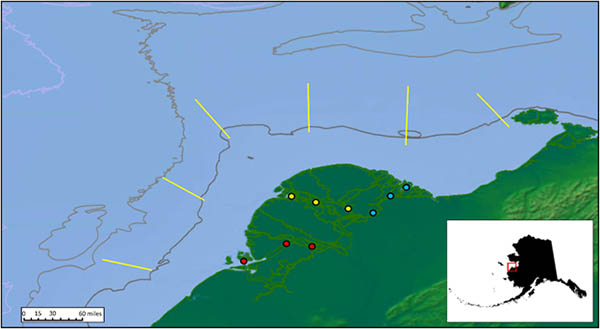
Figure 1. Sampling stations on the lower Yukon River and pro-delta. Red=south tributary, yellow = middle tributary, blue = north tributary, lines = pro-delta transects.
The Yukon River flows through the Yukon-Kuskokwim Delta, a large alluvial plain of sediment deposited by the Yukon and Kuskokwim Rivers over long periods of time. At its lower end, the Yukon River branches into three main tributaries (or mouths), each with numerous minor tributaries, sloughs, and channels. We partnered with local fishermen from the villages of Emmonak and Alukanuk to help us establish and sample three locations on each of the three mouths (Fig. 1). Although the Yukon River can be several miles wide, in many places it is extremely shallow. The river is constantly changing, and there are numerous shallow mid-channel bars that cannot easily be seen in the silty waters. Local knowledge of the river has been critical for success of this research.
At each of the sampling locations (or stations), we used a net towed between two outboard-powered skiffs to catch juvenile salmon and other fish. For each tow, we also collected information on water temperature, depth, and how fast the water was flowing through our nets. We sampled each station three times per week from the middle of May (just after the ice had left the river) to the end of July in 2014 and 2015.
As the Yukon River water passes the mouths of the tributaries, it spreads out across a subtidal area called the platform. The platform is large and extremely shallow, averaging less than 2 meters (6 feet) deep and extending as much as 30 kilometers (18 miles) off shore of the river mouths. Within the platform are a number of channels that have been scoured out by ice and river flow. Juvenile salmon must cross this platform as they head out to sea, but most of the area is too shallow to sample using trawls, and the water is too turbid to be able to locate the ice-scour channels that the fish may be using on their outmigration.
At its seaward edge, the platform drops off abruptly into deeper water in an area referred to as the delta front or pro-delta. The plume of freshwater from the Yukon River reaches all the way out to the pro-delta where it mixes with the marine waters of the northern Bering Sea. This is the seaward edge of the Yukon River estuary. We chartered the 42-foot fishing vessel Anchor Point out of Nome, Alaska, to sample five transects set perpendicular to the delta front (Fig. 1). These transects cross the river plume, the location of which changes seasonally throughout the sampling period, allowing us to intercept the fish as they begin the marine phase of their life.
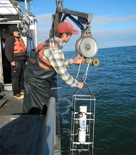
Setting the CTD instrument onboard the chartered fishing vessel Anchor Point. Photo NOAA Fisheries.
On each transect, sampling stations are located at the 7-m, 10-m and 14-m water depth contours. Surveys conducted by AFSC scientists in the Bering Sea regularly sample as shallow as 20 m near the Yukon Delta. The depths of our stations were chosen to extend sampling inshore to the edge of the pro-delta. At each of our sampling stations, we used a surface trawl called a Mamou to catch salmon and other fish in the top 2 m of the water column. At the 10-m and 14-m stations, we also used a midwater Aluette trawl to sample the water column between 2-m and 5-m deep. Together, these nets can not only help us fish the top 5 m of the water column, but also can help us determine whether the fish we catch are on the surface of the water or deeper down.
A CTD (conductivity-temperature-depth) instrument fitted with a turbidity meter was used to collect information on the physical environment at each mile along the transects. After processing the information on a computer, we can see vertical profiles of the water that show how the temperature, salinity, and turbidity of the water vary as we move from shallow stations to deeper stations, as we move around the delta, and as we sample over the summer. Delta-front fish sampling and oceanographic data collection occurred on cruises in June, July, and August of 2014 and 2015.
All of the fish and invertebrates that we captured, both in the tributaries and off the pro-delta, were identified to species and counted. A subsample of each species and/or age group was measured, and any species we could not identify in the field was frozen or preserved in formaldehyde to be brought back to the Center’s Auke Bay Laboratory in Juneau for identification. Because this is only the second survey to be conducted in this area since 1986, we also collected whole fish vouchers of each species for inclusion in the University of Alaska Fairbanks museum.
Chinook and coho salmon captured in the river or on the pro-delta were measured, bagged, and either frozen or placed in formaldehyde so that they could be brought back to the lab to be analyzed. The energetic status of a subsample of juvenile Chinook and coho was analyzed to understand the condition of the fish. Prey resources of juvenile Chinook and coho were evaluated by removing the stomachs, sorting the stomach contents by prey type, and weighing each component.