MIDWATER ASSESSMENT & CONSERVATION ENGINEERING (MACE) PROGRAM:
Multibeam Sonar Training Course
Paul Walline and Alex De Robertis attended the 32nd Shallow Water Multibeam
Sonar Training Course held at the AFSC 1-6 December 2003. The intensive
36-lecture 6-day course provided an overview of “processing and visualization
techniques designed to address the complexities of swath mapping,” and
included shipboard demonstrations of multibeam sonar equipment. Although
the course was designed primarily for hydrographic surveyors, the methods
described are of increasing interest for NOAA scientists tasked with characterizing
fisheries habitat and for MACE scientists interested in the use of multibeam
systems in midwater to detect fish to the side of research vessels. Use
of multibeam systems in midwater was not specifically addressed in the
course, but the basic principles taught can be directly applied to the
problem of using such systems for fisheries research. The new NOAA ship
Oscar Dyson will be equipped with a Simrad SM2000 Multibeam Imaging Sonar
operating at 90 kHz with a 90° field of view. Efforts are currently under
way to develop methods for calibration and to develop software for displaying
and analyzing SM2000 recordings.
By Paul Walline.
GIS Visualization of Acoustic Survey Data
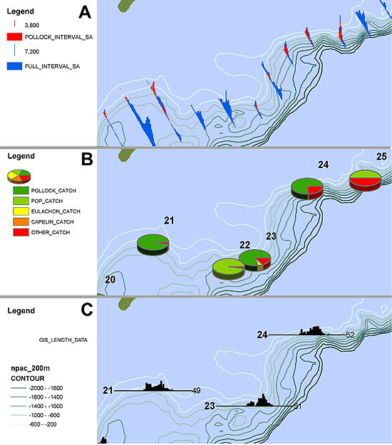
Figure 3. The GIS display includes both the total measured acoustic backscatter
and that portion attributed to walleye pollock (A). Primary biological data
of interest includes overall catch composition (B) and walleye pollock length frequency (C).
During the summer 2003 Gulf of Alaska survey aboard the NOAA ship
Miller Freeman, MACE scientists (with invaluable assistance from Steve Barbeaux
of the REFM Division) developed a GIS application to visually incorporate
basic biological and acoustical survey data in a single platform (Fig. 3 above).
This application could be utilized to view and process data in real
time during the survey and aid in analysis. The long-term goal is to incorporate
this data visualization project into a web-based application that would
feature a direct connection to the MACE database and allow access of acoustic-trawl
survey results to non-GIS users, including the general public.
By Kresimir Williams.
Fisheries Scientific Computer System Users Conference
RACE scientists Mike Brown, Kresimir Williams, Robin Harrison, and Jason
Conner attended the Fisheries Scientific Computer System (FSCS) Users Conference
in Silver Spring, Maryland on 2-5 December. The conference was sponsored
by the Office of Science and Technology in cooperation with NOAA Marine
and Aviation Operations (NMAO). The FSCS is a paperless system for collecting
trawl and biological data that was developed by NMAO and the Northeast
Fisheries Science Center during spring 2001. Currently four of the fisheries
science centers use the FSCS as one of their primary tools for collecting
data during trawl surveys. The conference was convened to review each
center’s experience with FSCS and to establish the requirements for its
next major release. Representatives from all of the fisheries science
centers were on hand for the meeting. Important discussion topics included
new developments in wireless and fisheries technology; a common data model
for collection of fisheries data during surveys; a new module for longline/trap
surveys; support for adaptive sampling; a plan for national training, documentation
and support; and a time line for the delivery of the next major release of FSCS.
By Mike Brown.
>>>continued

|

|
quarterly Oct-Dec 2003 sidebar
AFSC Quarterly
Research Reports
Oct-Nov-Dec 2003
Contents
Feature
Auke Bay Lab
National Marine
Mammal Lab
RACE Division
REFM Division
Quarterly Index
Quarterly Home
|
