Scientists with the AFSC’s Groundfish Asessment Program have expanded their mapping study of the Aleutian Islands to include Cook Inlet, Alaska. This work is part of a project using smooth sheets to provide better seafloor information for fisheries research. The Cook Inlet project includes the same smooth sheet bathymetry editing and sediment digitizing as the Aleutian Islands effort, but also includes:
digitizing the inshore features, such as rocks, islets, rocky reefs, and kelp beds;
digitizing the shoreline; and
replacing some areas of older, lower resolution smooth sheet bathymetry data with more modern, higher resolution multibeam bathmetry data.
The smaller area of Cook Inlet, greater amount of project time, and higher quality of smooth sheets than in the Aleutian Islands made these additions possible. The NMFS Alaska Regional Office's Essential Fish Habitat funding made much of this work possible.
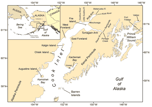
Bathymetry of Cook Inlet. Click map to enlarge.
Sediments of Cook Inlet. Click map to enlarge.
Bathymetry of Cook Inlet
A total of 1.4 million National Ocean Service (NOS) bathymetric soundings from 98 hydrographic surveys represented by smooth sheets in Cook Inlet were corrected, digitized, and assembled.
Overall, the inlet is shallow, with an area-weighted mean depth of 44.7 m, but is as deep as 212 m at the south end near the Barren Islands.
The original, uncorrected smooth sheet bathymetry data sets are available from the National Geophysical Data Center (NGDC), which archives and distributes data that were originally collected by the NOS and others.
Sediments of Cook Inlet
A total of 9,000 verbal surficial sediment descriptions from 96 smooth sheets were digitized, providing the largest single source of sediment information for Cook Inlet.
There were 1,172 unique verbal descriptions, with most of the sediment description categories (58%) only having a single occurrence. That means that most descriptions were fairly lengthy and specific.
Of the sediment descriptions which occurred more than once, Hard (n = 1335), Sand (n = 721), Rocky (n = 608), and Mud (n = 365) were the most common, which ranged from Rock to Clay, Sand ridges to Mud flats, Weeds to Stumps, and Mud to Coral.
The 20 most common sediment categories are depicted along a color gradient in the Figure, where red shows larger/harder sediments such as Rock, Rocky, and Boulders, and green shows smaller/softer sediments such as Mud, Soft, and Sticky.