Winter Surveys in Gulf of Alaska and Southeastern Bering Sea Near
Bogoslof Island
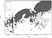
Figure 1. Click to enlarge map.
Scientists from the Midwater Assessment and Conservation Engineering (MACE) Program
conducted winter echo integration-trawl surveys aboard the NOAA ship Miller
Freeman in the Gulf of Alaska (GOA) and southeastern Bering Sea near Bogoslof
Island. The surveys provide data on the abundance, distribution, and biological
composition of spawning walleye pollock (Theragra chalcogramma).
Areas surveyed in the GOA during 15 - 19 February include the Shumagin Islands,
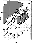
Sanak Trough, and Morzhovoi Bay (Fig. 1) and during 14-27 March included the
Shelikof Strait area and Chirikof shelf-break area (Fig 2). The area in the
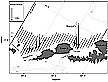
vicinity of Bogoslof Island in the Bering Sea was surveyed from 4 to 11 March
(Fig. 3). All surveys were conducted 24 hours per day.
Figure 2. Click to enlarge map.
The GOA survey results indicated that pollock abundance decreased in 2006 compared to 2005 in all areas except Sanak Trough where estimates nearly doubled in 2006. Nevertheless, localized dense adult pollock aggregations were observed in some of the surveyed areas. For example, relatively high fish densities were detected off Renshaw Point in the Shumagin Islands and in the northern part of Sanak Trough. Morzhovoi Bay was surveyed for the first time this year and the adult pollock densities were greater near the mouth, rather than inside the bay.
Pollock densities from the Chirikof shelf-break survey were relatively greater along the eastern portion of the shelf-break near the mouth of Barnabas Trough whereas in previous years, greater densities existed farther to the west (Fig. 2). In Shelikof Strait, the highest pollock densities were observed in the southern end of the strait proper in amounts similar to 2005. Lower densities of pollock were detected between Cape Kuliak and Katmai Bay than last year.
The adult pollock size compositions for the GOA surveys were generally unimodal
and centered around 50 cm fork length (FL). Age-1 pollock aggregations were
detected in the Shumagin Trough, whereas age-2 pollock (21 cm FL mode) were
broadly distributed in Shelikof Strait. Preliminary analysis of maturity stages
indicated that survey timing was appropriate for the Shumagin, Shelikof Strait,
and Chirikof shelf-break surveys but may be scheduled slightly earlier for
the Sanak Trough and Morzhovoi Bay surveys in the future.
Figure 3. Click to enlarge map.
The pollock abundance estimate this year for the southeastern Bering Sea survey near Bogoslof Island was similar to the 2005 estimate. Adult pollock were concentrated in two main areas: northeast of Umnak Island, and north of Samalga Pass, between the Islands of Four Mountains and Umnak Island (Fig. 3). Most pollock were in the Umnak region. Although the pollock size composition ranged between about 38 cm and 71 cm FL in both areas, the Umnak region was characterized by a unimodal distribution (45 cm FL mode), and the Samalga region was characterized by a bimodal distribution (48, 61 cm FL modes). Preliminary analysis of maturity stages indicated that spawning commenced earlier in the Umnak region than in the Samalga Pass area.