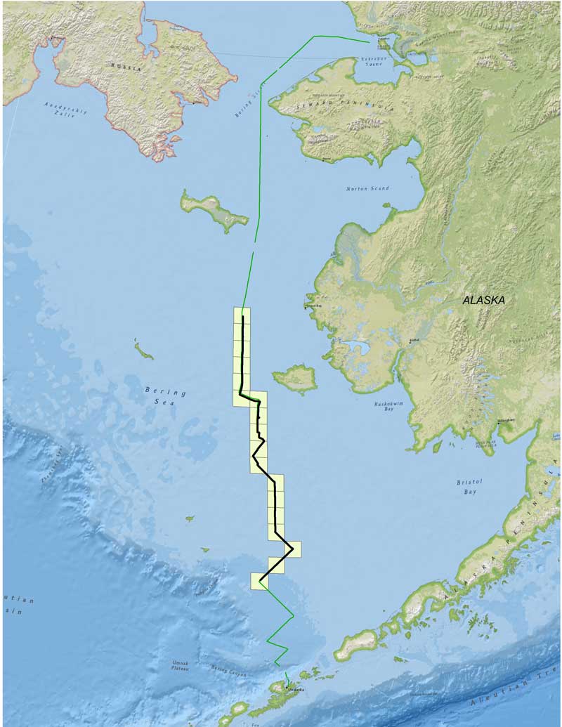
Figure 13. Trackline for the South Arctic Reconnaissance Survey by NOAA ship Fairweather, 1-6 August 2012. The bold line indicates the area surveyed with the Klein 7180 long-range side scan sonar (LRSSS) and is overlaid on the line indicating where backscatter and bathymetry were collected with the ship’s two multibeam echosounders. Yellow squares indicate trawl-survey locations characterized with the LRSSS. The transit covered 1,051 linear nautical miles. Click image to enlarge.
Figure 14. Free-fall cone penetrometer ready for deployment. Sensors in the body of the instrument measure deceleration as the device penetrates the seafloor and comes to rest below the surface, providing information about the vertical structure of sediments while the ship is underway. Another sensor in the yellow tail region measures sound velocities in the water column which are used to provide high-quality acoustic data.
The Arctic is becoming more accessible as perennial sea ice retreats. As such, there is an increasing likelihood of new fishing, shipping, and exploration activities in the region. Planning efforts by NOAA and others are underway but are often hindered by a lack of baseline information. For example, the North Pacific Fishery Management Council recently tasked the AFSC to synthesize existing ecosystem information and develop a research plan for understanding the effects of bottom trawls on the previously unfished northern Bering Sea shelf. Similarly, the NOAA Office of Coast Survey (OCS) has developed an Arctic Nautical Charting Plan “to build the foundation for Arctic shipping,” emphasizing the need to identify northern shipping routes and ports of call.
To address these needs, the OCS planned a reconnaissance survey from Dutch Harbor, Alaska, to Kotzebue Harbor on the NOAA ship Fairweather and invited AFSC Habitat Research Group (HRG) scientists to participate. Our scientific objective was to tow the Klein 7180 long-range sidescan sonar system (LRSSS) to investigate latitudinal trends in seabed characteristics (backscatter and bathymetry) and to continuously measure turbidity, colored dissolved organic matter and chlorophyll-a using the 660 nm (red) optical transmissometer on the LRSSS. These data will provide a first look at seafloor and water-column habitats in the area and could support an evaluation of potential sampling gears. The cruise also provided an opportunity for the OCS to consider utility of the towed LRSSS for reconnaissance surveying, as compared to more conventional ship-mounted systems.
The 2012 South Arctic Reconnaissance Survey followed completion of the scheduledFISHPAC cruise in the eastern Bering Sea. After a brief in-port period in Dutch Harbor, a team of three HRG scientists and two Navy technicians resumed survey operations on the Fairweather. The 1-6 August leg consisted of a northerly transit across the Bering Sea, through the Bering Strait to the Chukchi Sea, and into Kotzebue Sound, roughly 26 nmi north of the Arctic Circle. The trackline planned for this leg ran generally north to include 38 AFSC bottom-trawl-survey stations but was repeatedly modified due to poor weather and a significant westerly swell (Fig. 13).
During the transit, acoustic backscatter and bathymetry data were continuously acquired with the ship’s two hull-mounted Reson multibeam echosounders and the LRSSS. A free-fall cone penetrometer was used to collect sound velocity data and to characterize geotechnical properties of the seafloor (Fig. 14). The combination of poor weather and shallow water eventually prompted the suspension of LRSSS and penetrometer operations at a point to the west of Cape Romanzof. Sound velocity data were subsequently collected using a single-sensor free-fall instrument deployed with the ship’s computerized winch. Final LRSSS coverage included 18 AFSC bottom-trawl-survey stations; penetromenter drops were completed at nine of these.