Bottom Trawl Survey of the Aleutian Islands Region Completed
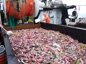
Large mixed catches of northern rockfish and Atka mackerel are common during bottom trawl surveys of the Aleutian Islands region. Photo by Nancy Roberson.
The fourth in the series of biennial bottom trawl surveys of Aleutian Islands (AI) region groundfish resources was conducted from 1 June through 11 August 2006. The full series of periodic AI surveys dates back to 1980. Prior to establishing a biennial schedule in 2000, these surveys had been conducted mostly on a triennial schedule by the RACE Division. Surveys conducted prior to 1991 were cooperative efforts involving U.S. and Japanese vessels and scientists. Since 1991 they have been planned and conducted entirely by the RACE Division.
The primary objective of the surveys is to provide a standardized time series of data to assess, describe, and monitor the distribution, abundance, and biological condition of AI region groundfish and invertebrate stocks. Additional objectives are to collect environmental data, such as surface-to-bottom water temperature profiles, and to make special collections of biological specimens and data requested by AFSC scientists and cooperating research groups.
The 2006 AI triennial survey area stretches over 900 nautical miles (nmi) from the Islands of Four Mountains (long. 170°W) to Stalemate Bank (long. 170°E), including stations on Petrel Bank. In addition, the region between 165° and 170°W along the north side of the archipelago is included as the Southern Bering Sea subarea. Stations range in depth from nearshore to 500 m.
Sampling was conducted aboard the chartered commercial trawlers Sea Storm, which was under charter for 70 days, and the Gladiator, which was chartered for 50 days. Sampling began near the Akutan Pass and progressed westward to Adak during the first 25-day leg. For safety considerations, the westernmost portion of the survey was completed at the beginning of the second leg, leaving the central portion for the final leg when the Sea Storm was operating alone.
Stations were allocated among 45 depth and geographic strata and were preselected randomly from a grid of potential sites overlaying the survey area. If untrawlable bottom, swift currents, or conflicts with active commercial fishing prevented sampling a station, a nearby alternate station was selected. Of 366 stations assigned to the vessels, 358 stations were successfully completed, ranging in depth from 32 to 484 m.
Over the total survey area, the most abundant species in 2006 were, Atka mackerel, Pacific ocean perch, northern rockfish, giant grenadier, arrowtooth flounder, walleye pollock, and Pacific cod in order of abundance. Increases in survey-wide estimated biomass since 2004 were observed for Pacific ocean perch by 16% to 667,000 metric tons (t); northern rockfish by 15% to 218,000 t; and arrowtooth flounder by 94% to 184,000 t. Survey-wide biomass estimates decreased for Atka mackerel by 36% to 741,000 t; giant grenadier by 22% to 193,000 t; pollock by 69% to 113,000 t; and cod by 19% to 93,000 t. Results have been supplied to stock assessment authors for updating assessment reports for the NPFMC.
Biological data and specimens were collected from a wide variety of groundfish and invertebrates. More than 96,000 length observations were recorded from 52 species. Length and individual weight measurements were recorded from almost 10,600 fish from 50 species. Over 7,800 pairs of otoliths were collected from 20 species, including 3 species of sculpin that were sampled for the first time this year.
By Mark Wilkins
FISHPAC Habitat Mapping Experiment on the NOAA Ship Fairweather
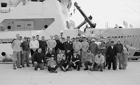
Figure 1. The FISHPAC field party consisted of scientists, engineers, and technicians from the RACE Division’s Habitat Research Team, the NOAA ship Fairweather, the University of New Hampshire Center for Coastal and Ocean Mapping, the U.S. Navy, and L-3 Communications Klein Associates. This was the first venture for the Fairweather into the Bering Sea since reactivation for hydrographic surveying and multimission research in Alaska.
The broad scope of the Magnuson-Stevens Fisheries Conservation Management Act’s essential fish habitat (EFH) mandate requires an efficient process for describing and mapping the habitat needs of federally managed species. For example, research indicates surficial sediments affect the distribution and abundance of many groundfish species, yet traditional sampling with grabs and cores is impractical over areas as large as the Bering Sea shelf. Acoustic tools, on the other hand, are suitable for large-scale surveying and show great promise as a substitute for direct-sampling methods, but they have not been proven for EFH purposes.
A multidisciplinary research team lead by RACE Division habitat scientists recently completed a dedicated multimission cruise in the eastern Bering Sea on the NOAA ship Fairweather (Fig. 1). The scientific objective of the FISHPAC cruise was to evaluate the utility of acoustic backscatter data for characterizing EFH, while simultaneously comparing the performance of five different sonar systems. The five systems included two hull-mounted multibeam echosounders on the Fairweather, a high-resolution interferometric side scan sonar, and a prototype long-range side scan sonar (LRSSS) with an independent single beam echosounder.
Teams with NOAA and the U.S. Navy installed most of the scientific equipment for the Bering Sea cruise when the Fairweather was in the port of Kodiak, Alaska, 13-17 July. Final mobilization in Dutch Harbor began 26 July, and the ship departed Dutch Harbor on 5 August after completing winch repairs and local gear trials. The vessel returned to Dutch Harbor on 20 August for demobilization and crew changes.
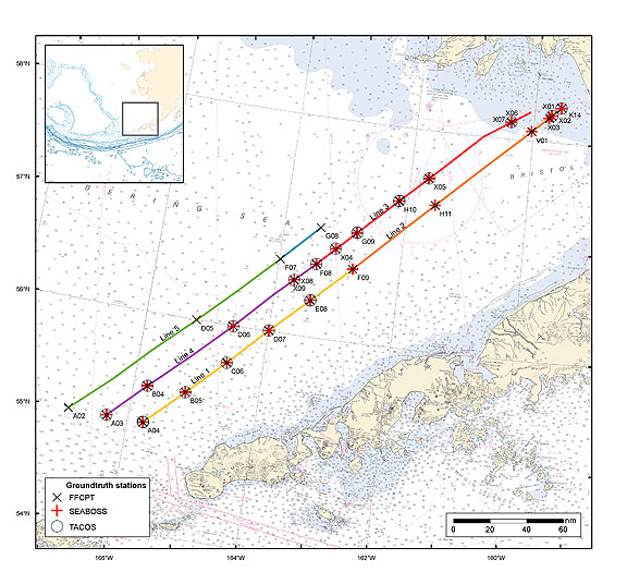
Figure 2. Summary of FISHPAC survey activities in the eastern Bering Sea. A free-fall cone penetrometer (FFCPT), a grab sampler with still and video cameras attached (SEABOSS), and a towed digital video system (TACOS) were used to characterize the seabed at selected locations.
The survey area consisted of six 140 nautical mile (nmi) tracklines on the Bering Sea shelf, with vertices at fixed RACE bottom trawl survey stations (Fig. 2). The tracklines were selected to span strong gradients of groundfish abundance as determined from many years of historical survey data. Each trackline was traversed three times for acoustic data collection and groundtruthing operations. In addition to acoustic backscatter and bathymetry data, light intensities, chlorophyll-a and particulate measurements, as well as sound velocities were collected with instruments mounted on the towfish.
Groundtruthing consisted of grab samples for sediments and infauna, penetrometer tests of sediment properties, and video tows at locations selected from side scan imagery. A total of 2,000 nmi were surveyed, and 25 groundtruthing stations were occupied. Statistical analyses will be used to identify the most cost-effective sonar system and operational guidelines for seabed mapping in the Bering Sea will be produced. The best performing system will be used to map and characterize the seabed of the Bering Sea shelf beginning in summer 2008. These data will then be used to update quantitative models describing the groundfish-habitat relationships in that area. Validity of these models will be examined with follow-up bottom-trawl sampling at selected new locations along the tracklines.
In addition to the scientific and technical benefits to EFH research, data collected during this cruise will also be used to update nautical charts in areas with outdated or nonexistent bathymetric information. The cruise was also an opportunity for design engineers to test the prototype LRSSS in a production environment. The LRSSS is a towed system capable of very broad coverage at somewhat reduced resolution and is being built to address NOAA’s need for more cost-effective survey tools. Additionally, the cruise supported a film team collecting footage for the NOAA 200th anniversary celebration, and the Fairweather surveyed an Atka mackerel spawning area near Dutch Harbor in support of ongoing RACE research.
By Bob McConnaughey
Groundfish Systematics Research
James Orr and Duane Stevenson continue working on the taxonomy and systematics of several families of fishes, most recently skates, snailfishes, rockfishes, sculpins, eelpouts, manefishes, and deep-sea anglerfishes. Both participated in meetings of the American Society of Ichthyologists and Herpetologists in New Orleans and the Charles Henry Gilbert Ichthyological Society in Newport, Oregon, where they presented papers on skate distribution and systematics.
Orr’s work with Sharon Hawkins of Auke Bay Laboratories (ABL) on the recognition, identification, and nomenclature of Sebastes melanostictus will be completed with the examination of important Japanese type specimens, which will be examined during an extended stay as a visiting professor to Kyoto in 2007. Stevenson’s paper synonymizing the name Stlegicottus xenogrammus with Rastrinus scutiger is in press, and he presented a paper on his work at the annual meeting of the Gilbert Ichthyological Society. His range extension and review of the morphology of Caristius in the eastern North Pacific with lead author Dave Csepp of ABL is in press.
By James Orr
Groundfish Stock Assessment Support
Estimates of abundance and size composition from results of the 2006 Aleutian Islands Bottom Trawl Survey were provided to the Plan Team and Resource Ecology & Fisheries Managment (REFM) Division stock assessment staff in the first week of October for inclusion in their groundfish population models for the 2006 NPFMC SAFE Report.