Groundfish Assessment
Bogoslof Island Mapping and Colonization
| |
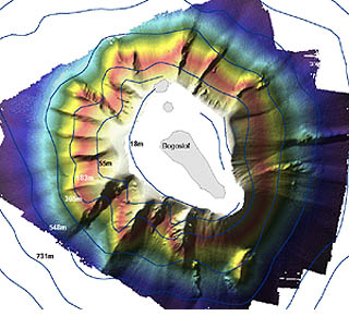
Figure 5. Preliminary bathymetric map of the seafloor surrounding Bogoslof Island, Alaska, from
approximately 20 to 750 m. Light areas indicate the shallows and dark areas indicate the deeps. |
We are studying the colonization process of benthic invertebrates at hard-bottom sites about 10-200 years old
on Bogoslof Volcano as a proxy for measuring recovery rates of benthic invertebrates from benthic fishing
activities. Bogoslof is a natural laboratory for our study because lava and tephra from historical eruptions
(since 1796) have resurfaced different areas of the shallow seafloor around the island, providing new surfaces
for benthic invertebrates to colonize. The results will provide information needed for fisheries management by
defining an upper bound on the time needed for recovery. Currently there are no reliable estimates of Habitat
Areas of Particular Concern (HAPC) recovery time from field work, and recovery rates on hard-bottom areas have
been estimated as 1%-9% per year whereas gorgonian coral recovery rates were estimated as 0.5-2% per year
(or 50-200 years) in the Habitat Recovery Model (EFH EIS).
The project involves three separate stages of research: mapping the seafloor, matching seafloor areas to specific
eruptions (dates), and conducting an ROV census of benthic invertebrates within seafloor areas of known ages.
The first phase of the project was completed in July 2004 when Fugro Pelagos (formerly Thales GeoSolutions, Inc.)
successfully mapped the seafloor surrounding Bogoslof with a 100-kHz Reson SeaBat 8111 multibeam from approximately
20 to 750 m (Fig. 5 above). After the final multibeam maps are delivered we will develop a census plan for studying the
invertebrates. In summer 2005 we plan to conduct remote operated vechile (ROV) transects within selected seafloor patches,
and we anticipate that there may be three possible levels of resolution for the video census: 1) presence/absence of
species or taxa groups, 2) density or percent horizontal coverage, and 3) age estimates of individuals.
By Mark Zimmermann (AFSC), Jennifer Reynolds (University of Alaska Fairbanks), and Chris Rooper (AFSC)
Reproductive Ecology of Atka Mackerel in the Aleutian Archipelago
Atka mackerel support a commercial fishery in Alaska and play a key role in the marine ecosystem. More
information regarding spatiotemporal distribution with respect to size, sex, and spawning condition, as
well as habitat use for nesting sites, is needed to understand Atka mackerel distribution patterns during
their reproductive phase. These patterns affect stock dynamics, recruitment, and distribution of Atka mackerel
populations. Timing, geographic location, and hydrographic features at nesting sites can affect the dispersal
of larvae and play a significant role in determining population structure. Variability in female reproductive
output (i.e., maturity schedule) can also contribute to variability in recruitment; however, it is unknown if
and how reproductive output varies over space and time. The specific objectives of this study are to 1) locate
and characterize nesting habitat; 2) analyze the spatiotemporal distribution of Atka mackerel populations by
reproductive stage, size, and sex; 3) describe the Atka mackerel embryonic developmental series over a range
of temperatures; 4) investigate the temporality of spawning, nesting, and hatching within and between nesting
sites; and 5) investigate the annual and spatial variation in reproductive output.
Exploratory underwater camera surveys have been used to locate Atka mackerel nesting sites in the U.S. Exclusive
Economic Zone (EEZ). The existing camera and the winch system were improved and refurbished so that they were
more reliable and could be used during summer 2004 on various vessels of opportunity in the Aleutian archipelago
and western Gulf of Alaska. During July and August, research was coordinated with the AFSC RACE Division’s 2004
Aleutian Island groundfish trawl survey. More camera drops were completed in September in conjunction with the
U.S. Fish and Wildlife research vessel Tiglax. The geographical coverage of camera drops was from
Stalemate Bank to Homer, Alaska. Numerous major nesting areas were located across the archipelago. The presence
of nesting male aggregations will be analyzed in relation to bottom depth, water temperature, and the physical
and biological habitat. The relationship of the nesting sites to other major geographic and bathymetric features
of the Aleutian archipelago will also be investigated using GIS. Results from these studies will be combined with
data from a histological analysis of gonad samples from Atka mackerel tag and tag recovery cruises.
The AFSC is also working with the Alaska Sea Life Center (ASLC) in Seward to do early life history research on
Atka mackerel. Live Atka mackerel were captured and transferred to the ASLC where they are being monitored for
spawning activity. During August and September, numerous clutches of eggs were spawned. Developing eggs are being
kept in special temperature-controlled incubators. Egg clutches at several different temperatures are being sampled
and preserved for producing egg developmental series. A video monitoring system was set up in the public viewing
tank so that “time zero” for any spawning events and, thereby the starting time for an egg incubation developmental
series, could be recorded.
By Bob Lauth
>>>continued

|

|
Quarterly sidebar
AFSC Quarterly Research Reports July-Sept 2004
Contents
Feature
ABL Reports
NMML Reports
RACE Reports
REFM Reports
Quarterly Index
Quarterly Home
|
