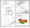
The first comprehensive mapping survey of the Pribilof Canyon area in the eastern Bering Sea (EBS) (Fig. 1) was completed June 2009 using high-resolution multibeam echosounders. Only sparse trackline data from reconnaissance and other opportunistic surveys have been available previously to describe the morphology of Pribilof Canyon, one of a family of huge canyons that play a central role in supporting the rich ecosystem of the Bering Sea.
Submarine canyons are significant geological features that cut the continental slope and function as conduits for organic and inorganic matter moving between deep basins and the continental shelf. The resulting fluxes can support diverse communities with high biomass, as compared to non-canyon regions at similar depths. Canyons are rare habitats, occupying less than four percent of the world seafloor and commonly contain unique species assemblages.
There are at least 15 distinct canyon systems along the EBS continental shelf, including the three largest submarine canyons in the world. Zhemchug is the largest of these; each of its two main branches is larger than typical continental shelf canyons (e.g., Monterey). Pervenets and Pribilof Canyons are substantially smaller. Two canyons (Middle, St. Matthew) were discovered as recently as 1982. Despite relatively extensive geological studies of submarine canyons in the EBS, very little biological information is available to assess the value of canyon habitats.
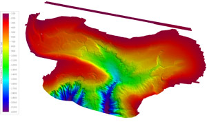
Figure 2. Preliminary multibeam bathymetry for a nearly 900 nmi2 area in Pribilof Canyon (20 m spatial resolution).
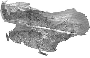
Figure 3. Preliminary multibeam backscatter in Pribilof Canyon (0.5 m spatial resolution). Shades of gray represent variations in seabed composition and texture
Planning for the Pribilof Canyon mapping project began in October 2008 when the Resource Assessment and Conservation Engineering (RACE) Division was approached by the Marine Conservation Alliance Foundation (MCAF), a diverse group of fishing and community organizations working to promote the sustainable use of North Pacific marine resources (on the web at www.marineconservationalliance.org/about.html). At that time, MCAF requested technical assistance to develop the first phase of a potentially longer-term study investigating the fisheries habitat features found in Pribilof Canyon and the potential impacts of derelict or lost fishing gear that form marine debris.
Based on a review of research priorities and existing knowledge of the area, it was decided to conduct a baseline hydrographic survey of the area with full multibeam bathymetric coverage and coregistered backscatter from the seabed. The resulting information would serve as the backdrop for developing scientific investigations of specific benthic habitats and associated organisms, as well as more exploratory work with manned and unmanned submersibles.
A unique and complex partnership was formed during the project planning period, consisting of three NOAA line offices (NMFS, National Ocean Service (NOS), Office of Oceanic and Atmospheric Research (OAR)), the University of Alaska Fairbanks, and MCAF.
The partners contributed technical expertise, personnel and/or funding to expand the original project scope from fishable areas of Pribilof Canyon (200-1,100 m depths) to include deeper canyon areas to 2,200 m. Two relatively small and shallow areas near the Pribilof Islands were also added because of potential importance as king crab habitat (total area 50 nmi2 ). The ensuing field operations conducted 2-17 June 2009 accomplished multiple coordinated objectives with efficient use of limited resources.
Overall, more than 1,200 linear nmi (approximately 900 nmi2 ) in the canyon were surveyed simultaneously with two high-resolution multibeam echosounders (70-100 kHz Kongsberg model EM 710 and 12 kHz Kongsberg model EM 120) installed on the chartered research vessel Mt. Mitchell.
Surveyors from Terrasond Ltd. with support from Lt.(jg) Meghan McGovern, a benthic habitat mapping specialist and NOAA Corps hydrographer assigned to the RACE Habitat Research Group, collected full-coverage bathymetry (Fig. 2) according to NOAA hydrographic specifications as well as the corresponding backscatter (Fig. 3).
After processing is completed, these data will be used to address the following mission objectives: 1) identify areas that are potentially hazardous for loss of commercial fishing gear and creation of marine debris, 2) produce quantitative measures of canyon morphology and habitat characteristics, and 3) provide high-quality hydrographic data for updating NOAA nautical charts and planning future research in the area.